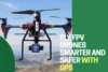
Drone GPS Systems Made Easy: Know How They Work
Published: 22 Jul 2025
Flying a drone without GPS can feel like driving a car with no map. You risk losing control, especially when the wind kicks in or the signal drops. That’s where GPS steps in as the hero. So, how does drone GPS work? It connects your drone to a network of satellites, helping it stay balanced, find its way, and return home safely. GPS gives both new and skilled pilots the control they need. In this article, we’ll break down how this simple tech keeps your drone steady and smart.
What Is GPS and Its Role in Drones
GPS, or Global Positioning System, is a group of satellites that send signals to devices like phones, cars, and drones. These signals help the device figure out where it is on Earth. In drones, GPS is used to find their exact spot in the sky. It tells the drone its location, how high it is, and which way it’s moving. This helps the drone fly in a straight line, stay steady, and return to where it took off. For example, if you are flying a drone over your backyard and suddenly lose control, GPS helps it safely fly back to the starting point without crashing. It’s like having a smart map built right into the drone.
How Does Drone GPS Work
Drone GPS works by using signals from satellites in the sky. These signals help the drone figure out exactly where it is.
Satellite Communication : Your drone connects to a group of satellites that are always orbiting the Earth. These satellites send out constant signals. The drone listens to at least four of them at the same time. This helps it figure out its position by comparing the distance from each satellite. This process is called triangulation.
Signal Reception : The drone has a GPS receiver, like the one in your phone. It catches signals sent by the satellites. Each signal carries timing and location information. By measuring how long it takes for the signals to reach the drone, it can tell how far it is from each satellite.
Position Calculation : Once the drone gets data from multiple satellites, it does the math. It calculates its exact location on Earth, including how high it is and what direction it’s facing. This helps the drone stay steady in the air, follow a path, and even hover in one place.
Example : Imagine four satellites in the sky and your drone below them. Each satellite sends a signal to the drone. The drone finds the spot where all the signals meet—that’s its location.
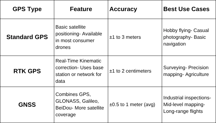
Types of GPS Systems in Drones
Key Features Enabled by GPS in Drones
GPS does more than just show the drone’s location. It unlocks smart features that make flying easier, safer, and a lot more fun. Let’s look at some of the most helpful GPS-powered tools:
Return-to-Home (RTH)
This feature brings your drone back to the exact spot where it took off. It’s super useful if the battery gets low or the signal drops. For example, if your drone goes too far and loses contact, RTH makes sure it flies back safely instead of crashing or getting lost.
Waypoint Navigation
This allows you to set a flight path on a map before takeoff. The drone will then fly through each point on its own. This is perfect for tasks like farm inspections or mapping large areas where the drone needs to follow a fixed route.
Geofencing
Geofencing creates invisible walls in the air. You can set limits so the drone doesn’t fly outside a safe area. This keeps your drone away from no-fly zones like airports or private property. It’s a great safety feature for beginners and pros alike.
Follow Me Mode
With this mode, the drone locks onto your GPS location and follows you wherever you go. Whether you’re biking, hiking, or running on the beach, the drone keeps you in the frame. It’s a fun tool for content creators and adventurers who want hands-free shots.
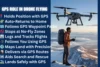
Benefits of GPS in Drone Operations
GPS makes drones flying smarter, smoother, and safer. Whether you are a hobbyist or a professional, using GPS brings many advantages that improve how your drone performs.:
Enhanced Stability : GPS helps the drone hold its position in the air, even when there’s wind or light signal loss. This stability makes it easier to capture clear photos and videos. It also helps beginners feel more confident during flight.
Precision : GPS gives the drone accurate location data, which is super helpful for tasks like land mapping, 3D modeling, or roof inspections. Professionals use this accuracy to cover exact areas without flying over the same spot twice.
Safety : With GPS, drones can avoid danger zones by using geofencing. They can also return to their starting point if something goes wrong. This reduces the chances of losing your drone or crashing in a no-fly area.
Efficiency : GPS lets drones fly on preset paths and complete tasks automatically. This saves time and effort, especially in large-scale work like surveying farmland, inspecting power lines, or scanning construction sites.
Challenges of Drone GPS
While GPS helps drones fly smarter and safer, it’s not always perfect. Weather, signal strength, and the environment can affect how well it works. Below are some of the most common GPS-related challenges every drone pilot should know.
Signal Loss : In areas with poor satellite coverage, like dense forests, tall buildings, or tunnels, your drone may lose GPS connection. This can make the drone drift, lose direction, or fail to return home.
Interference : Nearby power lines, radio towers, or even bad weather can disturb GPS signals. When this happens, drones may become unstable or fly with reduced accuracy.
Dependence on GPS : Relying too much on GPS can become a problem. If GPS fails, many pilots don’t know how to control their drone manually. This can lead to panic or crashes.
System Limits : GPS doesn’t always work indoors or underground. Drones that rely only on GPS won’t function well in those environments without alternative systems.
GPS-Denied Environments and Alternatives
Not every place allows drones to use GPS. Some areas block or weaken satellite signals. These are called GPS-denied environments.
Challenges Without GPS : Without GPS, drones can’t hold their position, return home automatically, or fly along a fixed route. They may drift, lose balance, or crash into objects. It becomes harder for the pilot to control the drone, especially in tight or unfamiliar spaces.
Alternative Technologies : To solve these problems, many drones use extra sensors. Visual Positioning Systems (VPS) use cameras to read the ground below and stay stable. LiDAR (Light Detection and Ranging) helps drones scan their surroundings and avoid obstacles. Some drones also use barometers, compasses, and optical flow sensors to stay on track.
Conclusion
GPS is a key part of what makes drones smart, stable, and easy to fly. It helps drones know exactly where they are, stay steady in the air, and return safely to their starting point. From taking smooth photos to flying set routes, GPS powers many important features that both beginners and professionals rely on.
If you’re thinking about getting a drone, always check its GPS capabilities. A strong GPS system can make a big difference in how safe and smooth your flights will be.