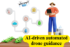
Fly Smarter with Drones Using Lidar and AI Technology
Published: 29 Aug 2025
Drone navigation with Lidar and AI may sound complex, but it works step by step. First, Lidar scans the surroundings using light signals. Next, it gathers accurate details about shapes and distances. Then, AI studies this data and makes quick flight choices. Finally, the drone follows these directions to fly safely and avoid obstacles. This process repeats every second, keeping the drone sharp and reliable. With this system, drones are now used in construction surveys, traffic monitoring, and environmental studies, proving their role as smart and practical helpers.
Poor Visibility and Hidden Obstacles
One of the biggest challenges for drones is flying safely when visibility is low. Human eyes and normal cameras often miss small or hidden objects, which can cause crashes or delays.
Hidden Wires and Poles : Drones can easily miss thin wires, street poles, or cables, especially when flying at higher speeds. These obstacles are hard to detect until it’s too late.
Low-Light Struggles : Normal cameras don’t perform well at night or in foggy areas. Without enough light, the drone may fly blind and fail to spot dangers.
Crowded or Narrow Space : Flying between tall buildings, trees, or tight corners is risky. Drones often lose track of small gaps and may crash while trying to navigate.
Slow Human Reaction Time
When drones rely only on human pilots, their safety depends on how fast the pilot reacts. But in fast or crowded flights, even a short delay can create big risks.
Limited Reaction Speed : Human eyes and hands cannot always respond instantly. A sudden bird, wire, or moving vehicle can appear before the pilot has time to act.
High-Speed Flying Risks : Drones move quickly, and at high speeds, just one or two seconds of delay can lead to crashes or lost control.
Crowded Airspace Challenges : In cities or event spaces, drones face unpredictable obstacles. Pilots often struggle to make fast, accurate choices when there is too much going on.
Inefficient Mapping Methods
Mapping large areas is one of the most common tasks for drones, but older methods are often slow and risky. Without smart navigation tools, drones and humans waste time and face unnecessary dangers.
Time-Consuming Surveys : Traditional surveys require more flying time and multiple trips to cover one site. This slows down projects and increases costs.
Higher Effort for Pilots : Manual checks demand constant attention from pilots. They must guide the drone carefully, which can be tiring and less accurate.
Risks in Tough Terrains : Forests, mountains, or construction zones are difficult to map manually. Pilots may face safety risks, and drones can miss key details.
Lidar Scans Like a 3D Torch
LiDAR drones make surveying safer, faster, and smarter. Think of Lidar as a torch that doesn’t just light up spaces but actually measures them. By sending out tiny light beams, it allows drones to see the world in 3D with amazing accuracy.
Light Beams as Eyes : Lidar shoots thousands of laser-like signals every second. These signals bounce back and tell the drone the exact shape and size of objects.
Detailed 3D Maps in Seconds : Instead of flat images, drones get a real-time 3D view. This helps them understand heights, gaps, and distances with precision.
Safe Navigation in Complex Areas : With Lidar, drones can detect hidden wires, narrow spaces, or crowded zones that normal cameras miss.
Real Example : Imagine a drone mapping tall buildings or busy traffic from above. Lidar creates a clear 3D map instantly, guiding the drone safely and accurately.
AI Makes Smart Flight Decisions
AI navigation drones act like the brain of the aircraft. Once Lidar scans the surroundings, AI navigation drones quickly process all the data to guide the flight safely. They choose the best route, avoid obstacles, and react faster than human pilots, making every mission smoother and more efficient.
Instant Data Analysis : AI studies the 3D map from Lidar in real time. It identifies obstacles, gaps, and safe paths instantly.
Smart Route Planning : Based on the map, AI chooses the best route for the drone. It avoids collisions and ensures smooth flight.
Faster Than Human Pilots : Humans take seconds to react, but AI makes decisions in milliseconds. This reduces risks and improves accuracy.
How the Duo Solves Problems Together
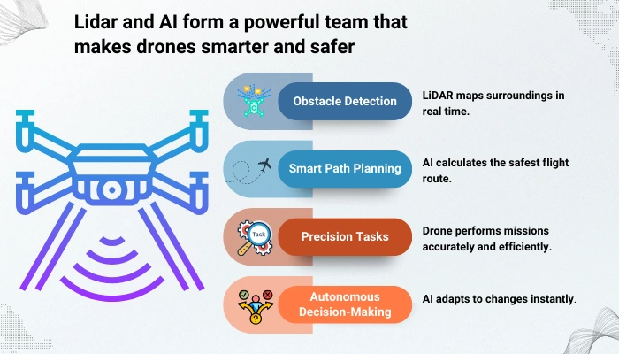
Lidar and AI form a powerful team that makes drones smarter and safer. Think of Lidar as the eyes and AI as the brain. Together, they solve problems that humans and normal cameras can’t handle.
Eyes and Brain Working in Sync : Lidar scans the surroundings continuously, while AI interprets the data and makes decisions instantly.
Avoiding Crashes : The combination detects obstacles early and navigates around them, reducing the risk of accidents.
Saving Time and Effort : With smart navigation, drones complete mapping, monitoring, or surveying tasks faster and more efficiently.
Real Example : Imagine drones scanning a busy construction site. The duo lets them move smoothly between cranes, wires, and workers without any collisions.
Smarter Guides, Brighter Torches
The future of drone navigation looks brighter than ever. With more advanced Lidar and smarter AI, drones will become even better at understanding their surroundings and making safe decisions. This means they could play important roles in disaster rescue, delivering medical supplies to hard-to-reach areas, or tracking wildlife in remote forests. As the technology improves, drones may soon fly with simple human guidance, handling complex tasks safely and efficiently. In short, the combination of Lidar and AI will turn drones into reliable, intelligent helpers for a wide range of real-world challenges.
Conclusion
Drones face real challenges, from poor visibility and hidden obstacles to slow human reactions and inefficient mapping methods. Thanks to Lidar and AI, these weaknesses are now strengths. Lidar acts like the drone’s eyes, scanning the environment in 3D, while AI acts as the brain, making instant decisions to avoid risks. Together, they guide drones safely and efficiently, transforming them into smart, reliable tools. Drones with Lidar and AI are not just flying machines, they are trusted helpers in the sky, ready to tackle complex tasks across industries and environments.
FAQs
Lidar is a technology that uses light beams to scan the surroundings. It creates a 3D map so the drone can see obstacles and distances accurately. This helps drones fly safely in complex areas.
Yes, they cost more than regular drones because of the advanced sensors and software. But the benefits—safety, efficiency, and accuracy—often outweigh the cost.
AI processes Lidar data in milliseconds. This is much faster than human reaction time. It allows drones to avoid obstacles instantly.